This article appeared in the February 2013 issue of Miranda News. It may not be reproduced without permission.
An internationally significant landform
Bruce W Hayward, founder and principal scientist with consultants Geomarine Research, explains why the chenier plain at Miranda is so important
|
| The Miranda chenier plain, which extends 15 km north and 2 km south of the Shorebird Centre, is an internationally significant landform. It is probably the best example anywhere of a Holocene coastal strand plain accreted by a combination of gravel and shell cheniers (beach ridges) that overlie intertidal mud. |
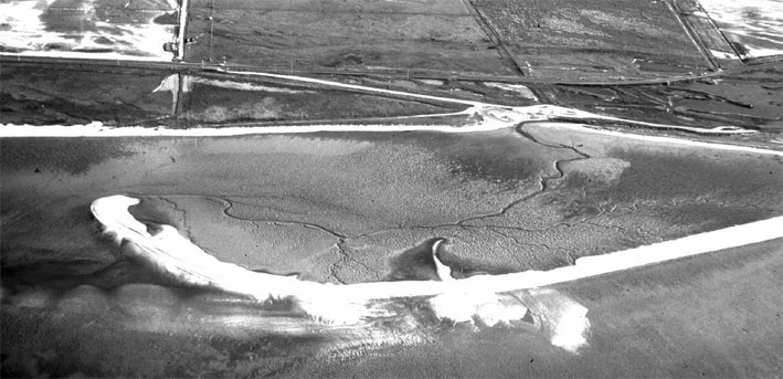
Aerial photo of a segment of the youngest chenier 500m south of the centre in 1980. It has since attached itself completely to the coast and advanced southward by 1.5km. Photo / Bruce Hayward
|
The gravel portion occurs in the north around Whakatiwai and is fed by greywacke pebbles eroded from the Hunua Ranges. These pebbles are moved southwards during coastal storms and become more rounded, smaller and less common towards the south, where they are replaced by vast masses of shells, dominantly cockle. The southern two thirds of the chenier plain was created by the accretion of a sequence of shell cheniers over the last 4000 yrs. Jim Schofield’s 1960 surveys showed that the oldest and most landward shell ridge has its crest and base approximately 2 m higher than the present day coastal beach ridge. A sequence of eight cheniers (numbered 13 to 6) aged between 4000 and 1000 years old extends seaward forming a 2 km wide plain and the cheniers become progressively lower. There has been considerable debate on how to interpret this. Schofield (1960), Dougherty and Dickson (2012) and Woodroffe et al. (1983) inferred that they recorded an actual sea level fall over this period of about 2 m, 2 m or 0.8 m respectively. Gibb (1986), Liefting (1988) and other workers have suggested that the difference in height can all be explained by slow tectonic uplift on the west side of the Hauraki Graben and differences in historic storm surge heights. In a number of other places around New Zealand and the Southwest Pacific there is well-dated evidence for sea level being 1.5-2 m above present level around 3,000-4000 years ago.
|
| I believe that over time most workers will accept that the Miranda chenier plain deposits provide perhaps the best record in New Zealand of mid-late Holocene (last 5000 years) sea-level variation in our part of the world. Dougherty and Dickson (2012), who used ground piercing radar to map the buried contacts between the shell ridges and the underlying mud, contend that the distance between the various cheniers may relate to the speed of sea-level fall at the time.There was a major change in the nature of shell ridge accretion about 1000 years ago switching from seaward advance to southward migration. All the younger shell cheniers are roughly the same elevation and suggest that the change was due to a switch from falling sea level to one that has been stable or in the last 150 or so years has been rising rapidly. |
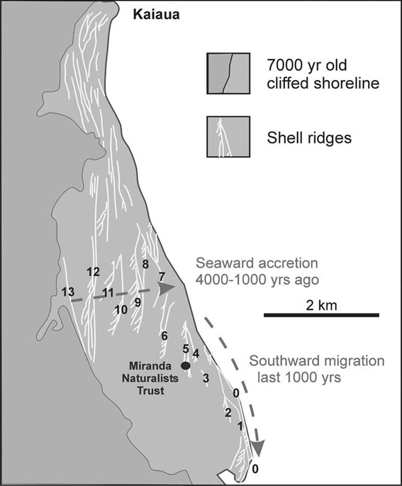
Map showing the shell chenier ridges mapped and numbered by Schofield (1960) forming the southern half of the Miranda Chenier Plain. Cheniers 13 to 6 accreted onto the seaward edge of the plain between 4000 and 1000 years ago during a period of overall sealevel fall of perhaps 1.5-2m. The subsequent cheniers (1-5) have all advanced southward in the last 1000 years during an interval of relatively stable and more recently rising sea level. The youngest chenier (0) has accreted since the formation of the Centre
|
The Shorebird Centre is built on the shell chenier numbered 5 by Schofield. Although it has not been directly dated, its age is inferred to be somewhere between 500 and 1000 years. Seaward and to the south of the centre are five more major cheniers (shell ridges) with splays and numerous overbank featherings all of which have accumulated since chenier 5. The land area seaward of the road has all accreted within the last 500 years and since the Miranda Naturalists’ Trust was formed a whole new chenier has been added across the seaward front of this section of coast. I have numbered it 0 on the accompanying map as it was not numbered by Schofield in 1960 as it did not exist at that time.This youngest shell spit’s growth and migration has been documented in a series of air photos since it first appeared as an arcuate offshore shell bank located just off from the shorebird centre in a 1969 photo. It migrated shorewards with the north end attaching to the existing shell beach by 1977. The shell ridge then straightened out parallel to and about 150 m seaward of the coast by 1988 and since then the accumulating shells have advanced the southern tip of the chenier another 1 km south almost to the mouth of the Miranda Stream. Over the same period the chenier has advanced shoreward by another 30-60 m. In the past 30 years the tip of the shell spit has migrated an average 50 m southwards per year.
It has been suggested that new cheniers at Miranda are initiated by northeasterly, possibly subtropical, storms with sufficiently large waves to winnow away vast quantities of intertidal mud in suspension and concentrate the remaining sand and shell into an offshore arcuate bar. In later storms, waves progressively add more shells to the bar and drive it shoreward. Coincidentally, the first appearance of the offshore bar that developed into the modern chenier at Miranda was in a 1969 airphoto not many months after one of the largest storms in the last century, Cyclone Giselle, passed over the Firth of Thames in April 1968 (Wahine Storm).
At Miranda the offshore bar is usually oriented at an angle to the shoreline and perpendicular to the inferred northeast winds and waves that move it. When the northwestern end reaches the existing shoreline it tends to anchor the shell barrier and the remainder of the bar straightens out parallel to the shore and over time its southern end advances down the coast. |
| For the majority of the time the shell beach ridge is stable, but in storms further shells are brought ashore and high tide storm waves may wash over the crest of the chenier producing a feathering effect with arcuate lobes of displaced shells. Over time, storm waves throw shells up onto the crest of the youngest chenier and this tends to stabilise it and stop further landward migration as waves no longer wash over it moving the shells with them. Once the new chenier becomes attached, the gap between it and the old beach ridge becomes a quiet backwater that accumulates mud. The mud builds up, mangroves and salt marsh become established and their roots help accumulate further sediment eventually to supratidal elevations creating additional dry land. Sometimes, as is the case with the modern chenier, the elongate shore-parallel gap between the new and previous shell ridges becomes the channel for a small tidal stream that may assist in preventing the youngest chenier advancing further landward.Thus the strip of land seaward of the road from the shorebird centre southward is a complex of young shell cheniers and their feathery washover lobes separated by lower elevation areas of accumulated salt marsh mud. Nearer the coast these low areas still support salt marsh and salt meadow communities that are periodically inundated by spring high tides. Closer to the road some of these elongate depressions become shallow ponds after heavy rain and exceptionally high tides. In the southern area some of the original cheniers and salt marsh flats have been modified by quarrying by the former Miranda Limeworks operations (1930s-1950s).
The future of this part of the Miranda chenier plain is hard to predict as sea level is currently rising faster than it has at any time in the last 5000 years when the present strand plain began to accrete. Undoubtedly this rise is already causing erosion of the shore to the north around Kaiaua. At the moment the supply of sand and shell to this southern end of the Miranda chenier plain is outstripping the inevitable erosive effects of sea level rise. For how long this will last we do not know. Will the mud coming down the Hauraki Plains’ rivers help offset the oncoming erosive phase? Only time will tell. |
|
|
|
References
Dougherty, A.J., Dickson, M.E. 2012. Sea level and storm control on the evolution of a chenier plain, Firth of Thames, New Zealand. Marine Geology 307–310: 58–72.
Gibb, J. 1986. A New Zealand regional Holocene eustatic sea-level curve and its application to determination of vertical tectonic movement. Royal Society of New Zealand Bulletin 24: 377–395.
Liefting, H.C.C. 1988. Development of the Kaiaua-Miranda Chenier plain. Unpublished Master’s dissertation, University of Waikato.
Naish, T.R. 1990. Late Holocene mud sedimentation and diagenesis in the Firth of Thames: bentonites in the making. Unpublished master’s dissertation, University of Waikato.
Schofield, J.C. 1960. Sealevel fluctuations during the last 4000 years as recorded by a Chenier plain, Firth of Thames, New Zealand. New Zealand Journal of Geology and Geophysics 3: 467–485.
Woodroffe, C.D., Curtis, R.J., McLean, R.F. 1983. Development of a Chenier plain, Firth of Thames, New Zealand. Marine Geology 53: 1–22.